Sea level rise resiliency planning along the Union Pacific Coast Subdivision between Albrae and Alviso.
Study Overview
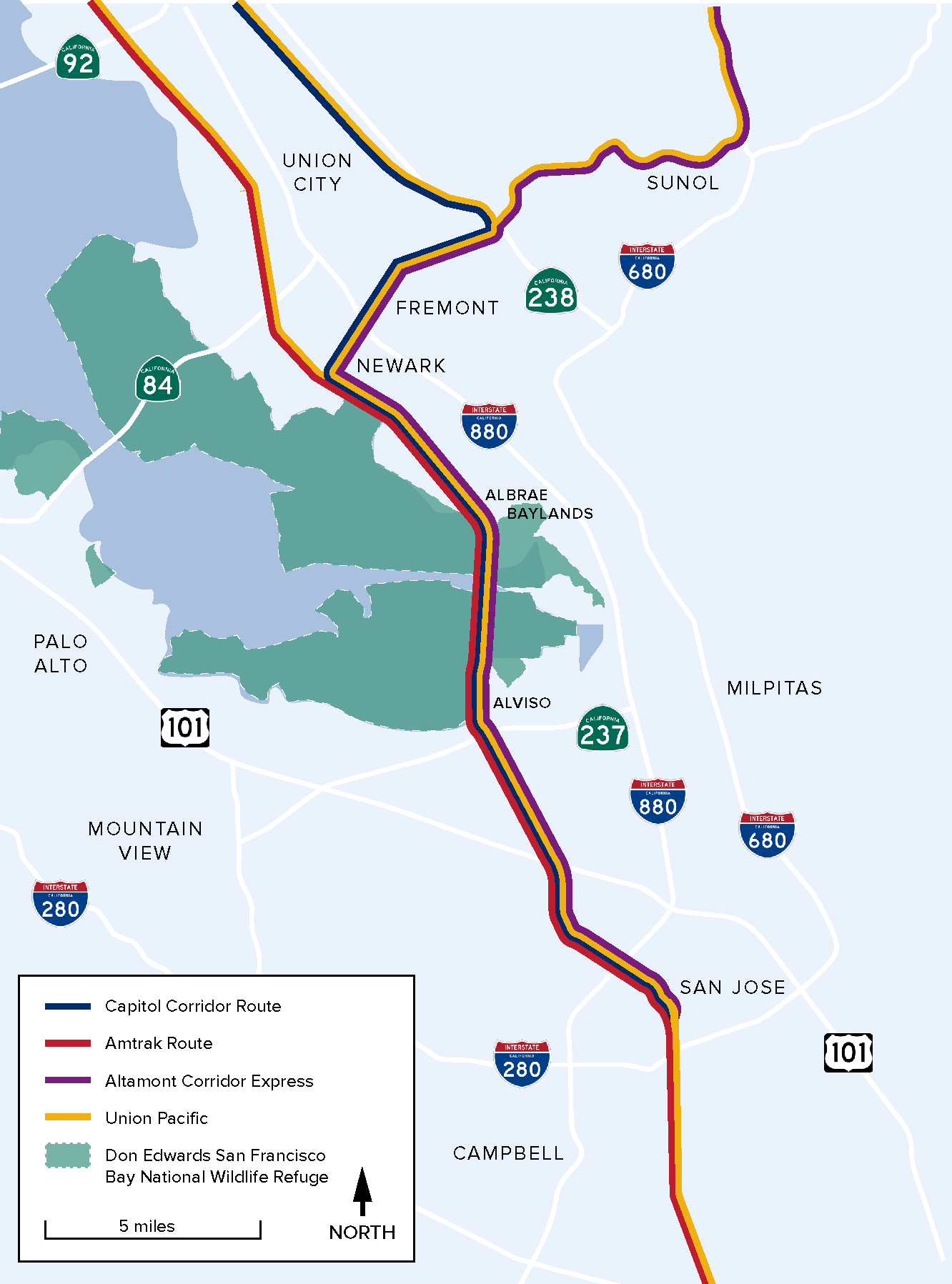
The Union Pacific Railroad Coast Subdivision between Albrae and Alviso in the south San Francisco Bay Area is a convergence point for multiple regional passenger rail services, and an important route for Union Pacific freight trains. Many rail operators rely on this corridor to provide their critical passenger and freight services:
- Capitol Corridor Joint Powers Authority (CCJPA) operates up to 14 daily Capitol Corridor trains traveling between Sacramento, Oakland and San Jose.
- San Joaquin Regional Rail Commission operates eight Altamont Corridor Express (ACE) trains per weekday traveling between Stockton and San Jose.
- Amtrak operates two long-distance Coast Starlight trains per day traveling between Seattle, Oakland, and Los Angeles.
- Union Pacific, which owns the rail line, operates approximately six freight trains per day on this segment of the Coast Subdivision.
The section of rail line between Albrae and Alviso consists of a single track that traverses a low-lying wetland area, the Alviso wetlands, that will be subject to flooding with even a moderate amount of sea level rise. Flooding of the rail line would sever passenger and freight service between these areas, potentially affecting thousands of travelers each day, and impair freight movement.
From 2018-2020, CCJPA conducted an Alviso Wetland Railroad Adaptation Alternatives Study (Alternatives Study) with extensive stakeholder outreach to identify and evaluate preliminary sea level rise adaptation options in this corridor. The Alternatives Study developed preliminary adaptation alternatives that received positive feedback from multiple stakeholders and built a strong foundation for future phases of adaptation work in the Alviso wetlands corridor.
CCJPA and its partners are now undertaking the Alviso Railroad Adaptation Planning Study (Study) to directly build upon findings of the previous Alternatives Study and further engage stakeholders to develop refined railroad adaptation design concepts. At the conclusion of the Study, CCJPA will have an adaptation project that could advance to the environmental documentation and preliminary design phase.
Study Purpose and Objectives
The Study’s purpose is to develop concepts that adapt the corridor’s infrastructure for sea level rise, create redundancy via additional tracks that create long-term capacity of the railroad tracks serving passenger and freight rail services, and minimize negative environmental impacts to the adjacent sensitive wetland ecosystem and broader estuary.
To guide the Study, CCJPA established three main objectives:
| Improve railroad infrastructure resiliency to sea level rise | |
| Improve existing railroad infrastructure to provide more operational capacity | |
| Provide benefits for local and regional stakeholders |
Potential Benefits of a New Railroad Track Alternative
By adapting the railroad tracks to sea level rise and increasing the public transportation options to and from Santa Clara County, train riders and the general public will benefit from:
- More frequent and reliable passenger train service
- Less congestion on roadways as travelers use trains instead of cars
- Reduced greenhouse gas emissions as travel diverts from cars to more environmentally friendly trains
- Resiliency to sea level rise effects such as flooding and erosion
- Enhanced species and habitat restoration efforts
Alviso Wetlands Corridor Background
The Study will conduct sea level rise resiliency planning for the existing Union Pacific Railroad Coast Subdivision, along the corridor which runs through the Alviso wetlands, between Albrae (approximately milepost 34) in Alameda County and Alviso (approximately milepost 40) in Santa Clara County.
The railroad infrastructure in the Alviso wetlands corridor was constructed in the 1870s on non-engineered fill, which was adequate for the smaller trains of the 19th century. At that time, surrounding ground level was higher relative to existing water level. However, in the intervening years, ground subsidence combined with sea level rise has raised water elevation relative to the tracks. Today, in some locations, the track is only a few feet above existing water surface elevation, posing a significant inundation risk of this important rail corridor as sea level rise progresses. It is also a mostly single-track rail corridor, so there is very limited redundancy in case of a track outage that would disrupt passenger and freight rail services and cause train delays throughout the larger Northern California rail network.
The Alviso wetlands corridor is situated within a wetland complex that has been extensively altered and degraded over time for industrial and developmental purposes and today represents an ecological landscape mosaic. Impacts from sea level rise are anticipated to negatively affect these landscapes, and construction of landforms providing extratidal refugia and transition zone habitat is an important regional ecological restoration and adaptation objective – an effort towards which this study may contribute.
Study Timeline
The Alviso Railroad Adaptation Planning Study builds upon the efforts and conclusions of a variety of planning efforts previously conducted by both CCJPA and the San Joaquin Regional Rail Commission (SJRRC), the ACE passenger rail service operator, in this area, which discerned the sensitive nature of the surrounding landscape, identified actively invested interest groups and recognized expansion constraints of rail line capacity.
- 2002: Informal high-level review of infrastructure constraints performed
- 2014: Sea level rise vulnerability assessment along entire CCJPA corridor conducted
- 2017: Draft Environmental Impact Report developed by SJRRC for ACEforward
- 2020: Preliminary draft design and alignment options for railroad adaptation developed by CCJPA
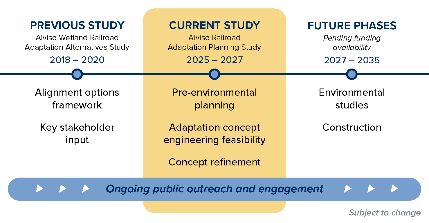
This Study directly builds upon stakeholder outreach and preliminary sea level rise adaptation options developed from the 2018-20 CCJPA Alviso Wetland Railroad Adaptation Alternatives Study. At the conclusion of this Study, CCJPA will have refined concepts for an adaptation project that could advance to the environmental documentation and preliminary design phase, pending funding availability.
The Study is anticipated to occur from 2025-2027, progressing through three major milestones that will include public and stakeholder engagement and refinement of adaptation concepts.

Engagement Opportunities
CCJPA believes that inclusive public involvement is essential to the planning process as well as improving decision-making and strengthening essential community partnerships. Stay involved to learn more about the Study and share your input.
Check back for details on upcoming engagement opportunities as the Study progresses and sign up below to be added to the Study contact list and receive regular updates.
Connect with us!
| Sign up here to be added to the Study contact list and receive updates on upcoming engagement opportunities. | |
| Email questions or comments about the Study to [email protected] | |
| Connect with us by phone Monday – Friday, 8am-6pm at 1-877-9-RIDECC (1-877-974-3322) | Telecommunications Devices for the Deaf (TDD) at 510-839-2220 |